
מדריך טיולים
מצא אטרקציות מובילות, מפות וטיפים לטיול באיי גלאפגוס.
מחפשים פעילויות באיי גלאפגוס? השתמשו במדריך זה להשוות אטרקציות מובילות, טיפים מקומיים, מפות ומזג אוויר.
פעילויות באיי גלאפגוס מתחילות בדרך‑כלל בטיולים חופיים מודרכים, שנורקלינג והליכות קצרות שמחברים צפייה בחיות עם סיפורו הגאולוגי של הארכיפלג ושל מאמצי השימור.
ישובים על Santa Cruz, San Cristóbal, Isabela ו‑Floreana משמשים כשערים לטיולי יום, שייטי לייב‑אברד ותחנות מחקר, בעוד כ‑97% מהאדמה מוגנת כפארק לאומי גלפאגוס כדי לשמר מינים אנדמיים ובתי גידול עדינים.

למה לבקר באיי גלאפגוס
מבקרים מגיעים לראות דוגמאות חיות של אבולוציה, נופי געש וחיות שמקלות על המפגש: צבי ענק במקלטי הרים, מושבות עופות מקננות במפרץ דרווין (Genovesa), תצפית Pinnacle Rock ב‑Bartolomé ומפגשים ימיים ב‑Kicker Rock.
חוויות רבות משלבות טיולי חוף מודרכים, הליכות קצרות ושנורקלינג/צלילה, כשהמטרה היא צפייה בלתי פולשנית ולמידה ממחקר ושימור.
פעילויות באיי גלאפגוס
ממרכזי מחקר והרי געש ועד סלעי ים מרהיבים ומושבות עופות מוגנות — האיים מעודדים חקר איטי ומודרך שמחבר מפגשי חיות לחינוך גאולוגי ושימור.
Charles Darwin Research Station (Santa Cruz)
The Charles Darwin Research Station (CDRS) in Puerto Ayora is the principal research and conservation hub for the Galápagos Archipelago. Founded in 1964 and operated by the Charles Darwin Foundation, the station translates scientific programs into public exhibits, education, and species recovery work.
Visitors experience a compact campus that blends interpretive displays, a small natural-history collection, a lookout tower with island views, and demonstration gardens that show native and introduced plant species.
A central feature is the Fausto Llerena Tortoise Breeding Center, where captive-breeding and repatriation efforts for giant tortoises are explained through interpretive panels and viewing areas.
El Chato Giant Tortoise Reserve (Santa Cruz highlands)
El Chato is a privately managed highland reserve on Santa Cruz Island known for accessible, in-situ encounters with free-roaming Galápagos giant tortoises.
The reserve preserves a mosaic of pastures, damp Scalesia forest, small lava flows, and natural tortoise wallows and ponds, providing a setting where tortoises come to feed, rest, and nest during seasonal movements between lowlands and highlands.
Visitors typically walk short trails and quiet dirt roads while guides point out tortoise behavior and highland plant communities.
The reserve matters because it allows observation of tortoises in their functional habitat, not a fenced zoo. Sightings can include adults, young animals, and tortoises using natural mud wallows to thermoregulate.
Bartolomé Island and Pinnacle Rock
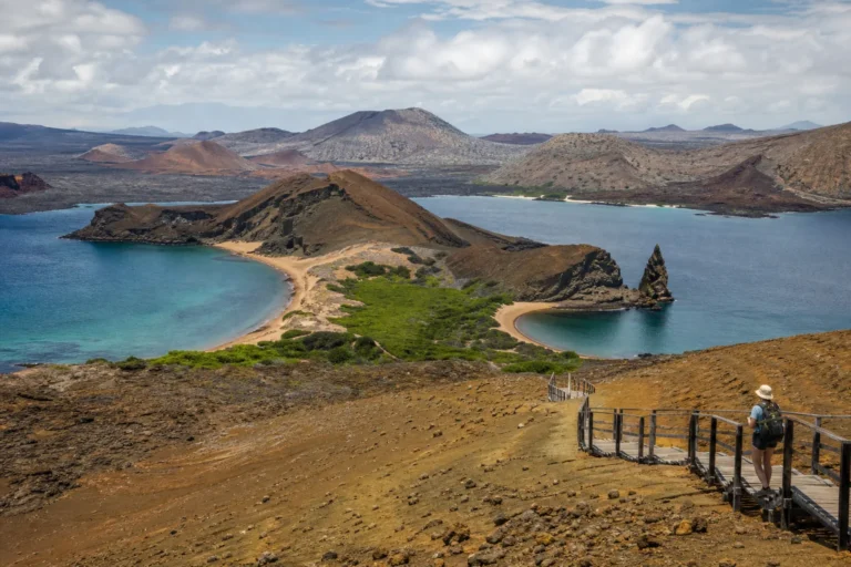
Bartolomé is a small, young volcanic islet best known for the iconic Pinnacle Rock. The rock is the eroded remnant of a tuff cone that formed when lava met seawater, producing the layered basalt-and-tuff spire that now rises near two small beaches.
Visitors arrive by zodiac or panga and encounter a landscape of black lava flows, spatter cones, and sparse pioneer vegetation that tells the islands’ volcanic story.
A maintained wooden stairway climbs to a 360-degree viewpoint on Bartolomé’s low volcanic cone. The ascent is short but steep, and the summit rewards visitors with panoramic views of Pinnacle Rock, the bay, and neighboring islands.
Kicker Rock / León Dormido (San Cristóbal)
Kicker Rock, locally called León Dormido, is a dramatic twin rock formation standing nearly vertically from the sea off San Cristóbal Island. Formed as a tuff cone that has been heavily eroded, the formation split into two tall pillars divided by a narrow channel.
From a distance the silhouette resembles a sleeping lion, which gives the site its local name and strong visual identity.
Visitors usually approach Kicker Rock by boat and enter the water to snorkel or scuba dive along the channel that separates the two pillars. The vertical walls and surrounding pelagic waters concentrate marine life, creating one of the archipelago’s most celebrated marine encounter sites.
Sierra Negra Volcano (Isabela Island)
Sierra Negra is a broad shield volcano at the southern end of Isabela Island, notable for its very large, shallow caldera and expansive lava fields. Visitors approach a landscape of dark pahoehoe and ʻaʻā lava, scattered fumaroles, and scrub vegetation that together illustrate recent volcanic processes.
The caldera floor itself is one of the most striking features, a shallow, broad bowl several kilometers across that gives a sense of the island’s dynamic geology.
The site matters because Sierra Negra shows how hotspot volcanism builds islands over time. Multiple eruptive centers and long lava flows on its flanks record repeated eruptions that reshaped Isabela’s coastline and interior.
Darwin Bay (Genovesa Island)
Darwin Bay occupies a shallow bay formed when Genovesa’s crater collapsed and flooded, creating steep cliffs, a coral-sand beach, and a sheltered lagoon. Visitors land by small boat onto a coral-pebble shore and follow a short, mostly flat trail that passes mangroves, saltbush, and low palo santo woodland.
The walk quickly moves into a dense seabird colony where birds nest at eye level, creating one of the archipelago’s most memorable birdwatching encounters.
The site’s significance is its extraordinary seabird assemblage, including large colonies of red-footed boobies, Nazca boobies, and great frigatebirds, plus swallow-tailed gulls and millions of storm-petrels.
Post Office Bay (Floreana Island)
Post Office Bay is a compact historical stop where human maritime practice became a living tradition. In the late 18th century whalers and passing sailors placed a sealed wooden barrel on the beach to leave addressed letters.
Other ships called by the bay would check the barrel and hand‑deliver letters that matched their destinations. That improvised, ship‑to‑ship postal system persists as a visitor ritual rather than a formal postal service.
Visitors arrive by panga and usually make a short, dry landing onto warm coral sand. The barrel sits near the shoreline and is easy to find; visitors commonly take and leave postcards there, continuing the old custom.
San Cristóbal Interpretation Center
The San Cristóbal Interpretation Center (Centro de Interpretación Gianny Arismendi) is the island’s principal public orientation to Galápagos nature and history. It presents layered exhibits on volcanic origins, ocean currents, species arrivals, and human settlement.
Panels, photographs, and models guide visitors through the archipelago’s natural processes and conservation challenges, offering a clear foundation before any field visits.
Exhibit topics include island geology and hotspot volcanism, Darwinian ideas and evolutionary processes, and the archipelago’s human timeline from sailors and settlers to modern conservation. The center emphasizes practical conservation work, describing invasive‑species control, scientific monitoring, and community education efforts that help protect endemic wildlife across the islands.
מתי הכי כדאי לבקר
לאיים יש אקלים תת‑טרופי שמווסת על‑ידי הים עם עונה חמה ולחה ועונה קרירה ויבשה. העונה החמה (בערך דצמבר–מאי) מביאה מי ים צלולים יותר, הריונות גבוהים ירוקים ופעילות רבייה של מינים רבים.
העונה הקרירה (בערך יוני–נובמבר) מציעה מים עשירים בפלנקטון שמושכים בעלי חיים ימיים גדולים וראיית צלילה מצוינת עבור פלגיים. תכננו לפי המועדים הביולוגיים של המינים שאתם רוצים לראות והיו גמישים בזמני המעבורות וההגבלות של הפארק.
הגעה ותנועה בין איים
אין דרכים ציבוריות המקשרות בין האיים; הגישה היא בטיסות מקומיות מורשות לנמלי באלטרה וסן קריסטובל או בסירות מהירות בין איים וצ'ארטרים פרטיים.
ביישובים הגדולים יותר משתמשים במוניות, מיניבוסים וקירבה להליכה כדי להגיע למרכזים, לחופי נחיתה ולמרכזי פירוש. אתרים מרוחקים מגיעים בטיולי יום בסירה או בשייטי לייבאבורד המופעלים בהרשאות פארק; תכננו את מסלוליכם לפי לוחות זמנים של מעבורות/טיסות וכללי הפארק.

מיקום
מפה של Galapagos Islands, Ecuador
המפה האינטראקטיבית נטענת רק כאשר בוחרים להציג אותה.
תכנון מעשי
הגעה ומעבר בין איים: רוב המבקרים טסים מאקוודור היבשתית (קיטו או גוויאקיל) לנמלי התעופה בבאלטרה או בסן קריסטובל. מעבר בין איים נעשה בטיסות מקומיות, מהירות או על ידי השכרת סירות וצ'ארטרים.
אתרים רבים ומספר נחיתות מוסדרים על ידי הפארק הלאומי גלפאגוס ודורשים מלווה מדריך טבע מוסמך ו/או אישורים. שירותים, דלק ומתקנים רפואיים מוגבלים על חלק מהאיים, לכן תכננו הזמנות וחילופי מתאר מראש והיערכו לאפשרויות חלופיות.
טיפים מקומיים
עטפו לשכבות ולקמפינג משני מזג אוויר: בגדי קלים לחופים לחים ולחות, וכן נעלי הליכה ופריט חם להרים הקרירים (El Chato, Sierra Negra). הביאו קרם הגנה בטוח לריף, בקבוק מים רב‑פעמי, שק יבש לטיולי סירה וציוד שנורקלינג אישי אם נוח לכם בכך.
חנויות גדולות מקבלות כרטיסים אך תביאו דולרים אמריקאים במזומן להוצאות קטנות, טיפים ומוניות באיים מרוחקים. הקפידו על כללי ביוסיקיוריטי: נקו נעליים וציוד לפני ההגעה ובהמשך בין איים, ופעלו לפי ההדרכות בשטחים מוגנים כדי להימנע מקנסות ולשמור על בתי הגידול.
תנאים נוכחיים
מזג האוויר הנוכחי

עודכן 2026-09-21 16:30
- מרגיש כמו
- 30°C / 85°F
- הגבוה / הנמוך היום
- 29°C / 83°F · 24°C / 75°F
- לחות
- 68%
- רוח
- ↓ 33 km/h
- משקעים
- 0.01 mm
- סיכוי לגשם
- 31%
- שעה מקומית
- 2026-09-21 16:35
בטיחות
הבטיחות בגלפאגוס מתמקדת בכבוד לחיות ובתנאי הים. שמרו על מרחק מומלץ מהיצורים, אל תתנו מזון ולא תגעו בבעלי‑החיים, ופעלו לפי הנחיות המדריך והפארק כדי למנוע עונשים ולשמור על רווחת המינים.
פעילויות ימיות עשויות לכלול זרמים חזקים וראות משתנה — השתמשו במפעילים מהימנים וחבשו אפוד הצלה כשמומלץ. שבילים הרריים והרי געש עלולים להיות תלולים ומשתנים; הביאו מים, הגנה מפני השמש והודיעו למדריך על מצב בריאותי.
אמצעי ביובקור בוחנים ומיושמים כדי להגן על המערכת האקולוגית—אל תעברו צמחים, חיות או אדמה בין איים.