
Travel Guide
Plan your visit around Yosemite Valley, Half Dome, and more of Yosemite National Park, California.
Discover the best things to do in Yosemite National Park, California, from signature sights to memorable local experiences.
Dramatic landscape centered on Yosemite Valley’s granite walls and waterfalls, plus high-country meadows and ancient sequoias. Signature features include Half Dome and El Capitan, Yosemite Falls, Glacier Point, Tuolumne Meadows, and the Mariposa Grove of giant sequoias.
A network of trails connects short valley walks to strenuous backcountry routes, while seasonal roads and shuttles link the park’s major viewpoints and trailheads.
Why Visit Yosemite National Park
Visitors come to Yosemite for its concentrated scenery, classic rock climbing, and accessible wilderness. The valley gathers iconic viewpoints—Tunnel View, Glacier Point, and Cook’s Meadow—so non-technical travelers can see Half Dome, El Capitan, and Yosemite Falls without multi-day travel.
Hikers range from those taking short, dramatic routes such as the Mist Trail to experienced parties attempting Half Dome or high-country treks from Tuolumne Meadows. Families and naturalists value the Mariposa Grove, seasonal waterfall displays, and interpretive programs that explain the park’s geology, ecology, and cultural history.

Top Things to Do in Yosemite National Park, California
Yosemite concentrates its biggest attractions into distinct areas—Yosemite Valley for classic views, Glacier Point for panoramas, Tuolumne Meadows for high-country access, and Mariposa Grove for sequoias. Below are the park highlights and how to approach them.
Yosemite Valley
Yosemite Valley is a nine-mile long, glacially carved corridor at the heart of the park, defined by meadows, the Merced River, and sheer granite walls.
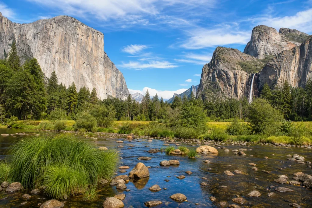
The valley concentrates world-class waterfalls—including the three tiers of Yosemite Falls and seasonal Bridalveil Fall—and classic viewpoints such as Tunnel View, Valley View, and the reflection at Sentinel Bridge that are especially photographable.
The valley also serves as a practical base for trailheads leading to short accessible walks or longer routes like the Mist Trail and John Muir Trail. Interpretive exhibits at the valley visitor center explain the park’s geology, ecology, and climbing heritage for first-time visitors.
Half Dome
Half Dome is Yosemite’s celebrated granodiorite monolith, rising roughly 4,700 feet above the valley floor and reaching about 8,836 feet above sea level. The classic route climbs from the valley floor past Vernal and Nevada Falls, then up the Subdome to the final exposed ascent made with a historic cable system.
The feature’s striking silhouette is a product of uplift and glacial erosion.
Hiking Half Dome demands strong fitness, careful planning, and a permit for the cable section. Many parties gain roughly 4,800 feet in elevation from the valley, so check permit rules and current trail and weather conditions before attempting a summit day.
El Capitan
El Capitan is a massive vertical granite monolith that dominates Yosemite Valley, rising roughly three thousand feet above the valley floor. From public viewpoints such as El Capitan Meadow and pullouts along the valley road, visitors can appreciate the cliff’s smooth face and monumental scale.
The formation is world-famous for big-wall climbing—routes that take days to ascend—and watching climbers on the face is a common visitor experience. Use designated viewpoints and obey closure signs; weather, rockfall hazards, and climbing activity affect safe access near the base.
Yosemite Falls
Yosemite Falls is one of North America’s tallest waterfall assemblies, made of Upper Yosemite Fall, the middle cascades, and Lower Yosemite Fall, with a combined drop around 2,425 feet. The falls are most powerful during spring runoff, while in other seasons they take on thinner, ribbon-like characters.
Visitors can experience the falls from paved loops to the base of Lower Yosemite Fall for close sensory impact or climb the Yosemite Falls Trail to the top for panoramic views. Expect mist, slippery rock near cascades, and variable trail conditions; always stay on marked paths and heed safety notices.
Glacier Point
Glacier Point is a high panoramic overlook about 3,200 feet above the valley floor that frames Half Dome, Yosemite Valley, Yosemite Falls, and the High Sierra beyond. A short paved, wheelchair-accessible path leads to the main edge where broad vistas and interpretive signs explain glacial history and landscape scale.
Access is typically by Glacier Point Road, which is seasonally subject to closure. Hikers reach the viewpoint via the Four Mile Trail or use it as a starting point for sunrise, sunset, and stargazing photography.
Check road conditions and limited services before you go.
Mariposa Grove of Giant Sequoias
The Mariposa Grove is Yosemite’s largest sequoia stand, with more than five hundred mature giant sequoias including named specimens such as the Grizzly Giant and the Fallen Monarch. Boardwalks and trails guide visitors among monumental trunks, illustrating sequoia ecology and conservation history.
Trail choices range from short accessible loops to longer hikes up toward Wawona Point and the upper grove. A welcome plaza and seasonal shuttle link the parking area with the grove trailheads to protect roots and improve visitor circulation; remain on designated paths to protect fragile soils and roots.
Tuolumne Meadows
Tuolumne Meadows is a broad, high-elevation subalpine meadow at roughly 8,600 feet elevation along the Tioga Road corridor. The flat grassland, threaded by the Tuolumne River and framed by glacially carved domes and peaks, offers open sightlines, summer wildflower displays, and access to the John Muir and Pacific Crest Trails.
Visitor services at the meadow are seasonal and limited compared with Yosemite Valley; the area is a starting point for day hikes, multi-day backpacking, and granite climbs on nearby domes. Tioga Road is seasonal—check official sources before planning travel to the high country.
Mist Trail (Vernal Fall & Nevada Fall)
The Mist Trail climbs steeply from Happy Isles beside the Merced River to Vernal Fall and on to Nevada Fall, bringing hikers into the waterfalls’ spray and often producing visible rainbows.
The paved first mile leads to the Vernal Fall footbridge; a steep granite stairway of roughly 600 steps gains the approach to Vernal Fall, and continued climbing reaches Nevada Fall’s powerful cascade.
The route is strenuous and can be very slippery in spring and early summer when spray wets the rock. Many hikers combine the Mist Trail with the John Muir Trail for a loop.
Wear traction-minded footwear, carry water, and check trail advisories before starting.
Best Time to Visit Yosemite National Park
Seasonal variety is a core strength. Late spring and early summer (May–June) bring peak waterfall flows and wildflowers.
Summer (July–September) opens Tioga Road and high-country hiking. Fall delivers quieter valley conditions and stable weather, while winter provides snow-dusted scenery, icy waterfall spectacles, and lower crowds.
Plan timing around your goals: waterfalls in May–June, alpine hiking and climbing in July–September, and snow activities or lower visitation in November–March.
Getting Around Yosemite National Park
Internal circulation mixes private vehicles, seasonal park shuttles, and limited regional transit. Several scenic roads—El Portal Road, Glacier Point Road, and Tioga Road—connect major areas but Tioga Road closes seasonally to snow.
A frequent shuttle serves Yosemite Valley, linking trailheads, parking, and visitor centers; valley walking and biking are convenient for short sightseeing. From gateway towns such as Mariposa, Oakhurst, Groveland, and Lee Vining, access depends on regional roads and scheduled shuttle services.
Always check current road and shuttle status before travel.

Location
Map of Yosemite National Park, California, United States
The interactive map loads only when you choose to view it.
Plan Your Visit to Yosemite National Park
Yosemite is large and heavily visited—plan logistics well in advance. Enter through staffed park entrances and expect delays and limited parking in Yosemite Valley during summer and holiday weekends.
Some activities require specific steps: Half Dome requires a permit for the cables. Mariposa Grove runs a seasonal shuttle from the Welcome Plaza and limits road access when the shuttle operates.
Glacier Point and Tioga Road are seasonally closed—verify official road status before you go.
Carry printed or offline maps and allow extra time for slow valley traffic and frequent pullouts.
Local Tips for Yosemite National Park
Base yourself in Yosemite Valley for immediate access to Yosemite Falls, El Capitan, and Half Dome viewpoints, and rely on park shuttles, walking, or biking to reduce parking headaches. For quieter alpine meadows and wildflowers, visit Tuolumne Meadows when Tioga Road is open.
At Mariposa Grove, arrive early or use the Welcome Plaza shuttle—plaza parking can fill by mid-morning. Bring layered clothing for the temperature swing between valley and high country, and wear sturdy shoes for granite trails and variable conditions.
Live conditions
Current Weather

Updated 2026-11-05 02:15
- Feels like
- 21°F / -6°C
- Today’s high / low
- 50°F / 10°C · 27°F / -3°C
- Humidity
- 70%
- Wind
- → 8 mph
- Precipitation
- 0 in
- Chance of rain
- 6%
- Local time
- 2026-11-05 02:21
Safety in the park
Yosemite’s natural hazards include steep granite, fast-moving water, wildlife encounters, and rapidly changing weather. Follow National Park Service guidance: stay on trails and away from lookout edges, avoid swimming near waterfalls or crossing unsafe currents, and keep a safe distance from wildlife.
Overnight wilderness travel and some climbs require permits and appropriate experience; carry navigation, water, and emergency supplies. Store food and scented items in approved bear-resistant containers or lockers.
In emergencies call 911 or contact park rangers at visitor centers.